Camera Systems
Basics of Aerial Photography
Aerial photography has three general uses:
- Cartographers and engineers take detailed measurements from aerial photos
- Trained interpreters use airphotos to map land use and all kinds of human activity
- Earth scientists use air photos to analyze and map the environmentAlthough both maps and aerial photos present a "bird's-eye" view of the earth, aerial photographs are not generally considered maps. Maps are spatially correct representations of the earth's surface; they are directionally and geometrically correct with regard to a planar frame of reference. Uncorrected aerial photos have radial distortion (due to lens curvature) as well as geometric distortions due to inconsistencies in the attitude of the airplane (roll, pitch and yaw). These limitations to accuracy are sometimes quantifiable in terms of scale, resolution and angular distortion but for the most part the "accuracy" of an air photo interpretation is a function of the experience of the interpreter and availability of ancillary information. Geometric distortions can be corrected but not always, this too is a function of the experience of the person doing it.
Photogrametry is, "the art or science of making measurements from aerial imagery". The geometry of an air photo is fixed by the altitude, focal length and film format. These three variables, along with measurements of the plane's three dimensional position relative to the ground, can be used to remove spatial distortions caused by topography, called "ortho rectification". By removing the geometric distortions and the topographic distortions aerial photographs can be used for very precise measurements.
Novice photo interpreters often encounter difficulties when presented with their first aerial photograph because objects are portrayed from an unfamiliar perspective. It's all a matter or experience, once you become familiar with interpreting aerial photography you will become better at identifying features and recognizing diagnostic patterns. It's simple, the more photos you look at the better photo interpreter you become.
Advantages of Aerial Photography over
Ground Based Observation
- offers an improved vantage point
- capability to take a "snap shot" of time that serves as a permanent record of changes
- broader spectral sensitivity than the human eye and much broader field of view
- better spatial resolution and geometric/radiometric fidelity than many ground based methods
- provides repetitive looks at the same area
- can focus in on a very specific wavelength range and distinguish subtle differences
- can also look at a number of wavelengths simultaneously
Why Process Remotely Sensed Data Digitally?
Humans are adept at visually interpreting images and learning patterns. Our eyes and brain are the most sophisticated remote sensing instruments there are, well beyond what machines will ever be capable of (even in the 21st century!) but computers do one thing better than we do - the same thing over and over and over again very quickly with flawless repetition. What our brains can to do far better than computers can is rule out illogical inferences; when we are presented with an image our brains immediately associate patterns with meanings, a computer has to match the pattern to something in a digital database. Although brute force computer horse power can effectively match patterns, with something as complicated as an aerial photograph it is doubtful that people will ever be replaced in this regard.Think of "precision" as the number of decimal places and "accuracy" as how well the results match the real world. In the field of air photo interpretation it is more important to be accurate with your reasoning rather than precise with your measurements. The products of human interpretations can be highly subjective, hence, not perfectly repeatable. Conversely, results generated by computer programs - even when they're wrong - are perfectly repeatable. Some foundation knowledge about camera systems and film will serve as a basis upon which to start becoming an air photo interpreter. Although technology has progressed significantly, the basic ideas describing cameras and film will continue to be relevant far into the future.
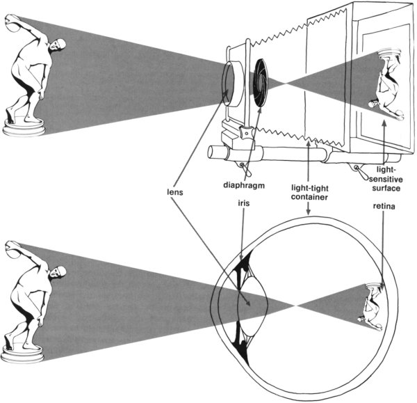
Camera Systems
Cameras are similar to your eyes; many of the mechanisms, including the geometry, are analogous. Cameras, like film, have undergone a steady evolution since they were invented. The reflex lens was crucial, as was film that would react quickly (and predictably) to light of different wavelengths. Camera lenses and filters are now a fully evolved technology. The following diagrams depict some fundamental ideas that pertain to the optics of cameras.
Camera vs. Eye Ball. Note the image inversion; this is corrected by mirrors in the camera body, and by our brains - the world your eyes see is really upside down! 
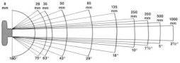
Focal Length vs. Lens Shape. Focal length is the distance between the lens and the point where the light rays converge. Magnification is controlled by distance from the object, film format, and/or the focal length. Lens curvature, optical purity and film quality also play a role. 

Focal Length
- For aerial systems, the amount of ground coverage acquired by a camera is a function of altitude of the platform, the focal length of the lens and the film format (size). Different camera systems have been developed for specific purposes, e.g. military surveillance where the balance between resolution, area covered and altitude has resulted in a multitude of different camera system configurations. The panoramic camera and the stereo strip camera are two examples of camera systems developed for specific tasks; panoramic cameras covered large areas and the stereo strip camera covered relatively small areas, from low altitude, in detail.
- A wider field of view will capture more area but sacrifice resolution. Digital camera systems are subject to the same physical constraints. Longer focal length, with lens diameter held constant, reduces image coverage but increases detail.
-

Focal Length vs. Size Size
Magnification, focal length, and angler field of view.
Fisheye


- The figures above illustrate the the relationship between distance (altitude) and focal length, as well as the relationship between aerial coverage and angular field of view. The figures below illustrate the tradeoff between lens diameter and object size. The pair of diagrams on the left shows the relationship between aperture, focal length, and magnification. Increasing lens diameter compensates for shorter focal length, but increasing lens aperture, focal length and film format, as is illustrated by the picture of the 40 inch focal length camera on the right, can greatly increase magnification and potential image detail.
-


Lens Aperture vs. Focal Length


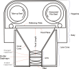
The main difference between aerial camera systems and traditional cameras is the need for aerial systems to be spatially accurate. Metric precision is necessary because aerial photography is often used to measure very small distances, and to create high resolution elevation models from stereo imagery. For these purposes it is necessary to have photography that is extremely accurate. It is possible to do your own photo reconnaissance by pointing a regular camera out the window of a plane and taking a picture of the ground, but in order to make reliable measurement you need a more stable setup. Certified "metric quality" cameras are expensive sensitive devices but necessary if precise/accurate measurements are required.Multispectral CamerasAerial cameras consist of essentially six component;
1. Lens Assembly; 3.5, 6, 8.25 and 12 inches are typical focal lengths. The lenses of aerial systems have the focus fixed at infinity.
2. Focal Plane; this is a perfectly perpendicular plate aligned with the axis of the lens, a vacuum system is used to fix the film to the plate so the focal plane is perfectly flat during exposure.
3. Lens Cone; this holds the lens and filter, and covers the front part of the camera preventing light from leaking into the camera body.
4. Body; encloses the camera, the mounting bolts and stabilization mechanism.
5. Drive Assembly; the guts of the camera, the winding mechanism, shutter trigger, the vacuum pressure system and motion compensation.
6. Magazine; holds the roll of unexposed film, advances the film between exposures, holds the film in place and winds-up the exposed film.
Aerial camera systems also have a mounting bracket, power supply, vacuum lines, heating jackets, filters, forward motion compensation (FMC) and an Interial Motion Unit (IMU). Also part of the system is a viewfinder for targeting the camera, an intervalometer that determines the rate at which exposures are taken (the amount of overlap) as the plane flies along the flight path, a navigation control system and an exposure control system. Computers have assumed many of these tasks which were once manual/mechanical. Global Positioning Systems (GPS) are now integrated into the camera system to provide very precise in-flight positional control.

Multispectral cameras were the precursor to the development of digital mulispectral satellite remote sensing systems. Different configurations of cameras, lenses, filters and film types were experimented with to determine optimal wavelength regions for the remote sensing of different landscape features. These experiments led to the selection of the multispectral wavelength ranges, or "bands", that were later used for satellite based remote sensing systems.Some Military Camera Systems

Left: Four Hasselblad 60 mm cameras setup to acquire synchronized multispectral images using different filters.
Right: BW CIR film using four filters; A blue filter, B green filter, C red filter, D near IR filter.

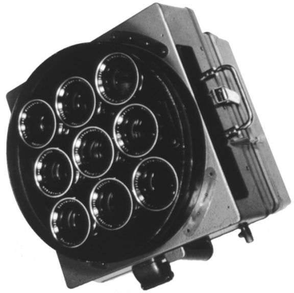
9 Lens Multispectral Camera


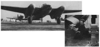
WWII Mosquito being loaded with 700,000 candlepower photoflashes in the bomb bay to take high definition flash pictures of the ground surface at night.

K-25 WWII Recon Camera

- KA-18A Stereo Strip Camera
The Stereo Strip Camera demonstrated its military surveillance potential in a time when near real time high resolution images were of the utmost importance. These cameras were pulled out of storage specifically for the task of low level high speed reconnaissance. Prior to the Cuban Missile Crisis, they were used in WWII and for determining the winner of horse races that were too close to judge by the human eye.
It does not use a shutter like a regular camera, but instead uses a slit. The film rolls past the slit with the same proportional speed of target, which in the case of aerial photography is the speed of the plane. Two contiguous strips of stereo photography are produced which would not be possible using a conventional shuttered camera and image motion compensation because low flying jet aircraft move way too fast. More Info


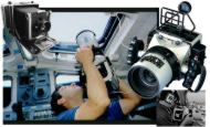
- Ektachrome 64 mm & Hasselbladd 500 EL/M 70 mm Cameras
- NASA has modified standard off-the-shelf Hasselblad 70 mm cameras (right in the image below) to operate in zero gravity aboard the Space Shuttle. A data recording module (DRM) has also been installed on each camera to record the date, time, mission number, roll number, and frame number on each exposure. The camera utilizes a 70 mm film format and uses one of three lens (50, 100, or 250 mm) to acquire high quality photographs through the four viewing ports on the Shuttle. The Ektachrome 64 mm camera was also used aboard the Space Shuttle.
- Gateway to Astronaut Photography of Earth: http://eol.jsc.nasa.gov/sseop/
- Lihof Aero Technika
 Ektachrome 64 mm & Hasselblad 70 mm cameras. |
NASA has modified the Linhof cameras to operate in zero gravity on board the Space Shuttle as well. The camera utilizes a five-inch film format and is equipped with interchangeable lens (90 mm and 250 mm). A data recording module (DRM) is also mounted on the camera to record the date, time, mission number, roll number, and frame number for each photograph. http://www.linhof.de/english/

- Large Format Camera
The Large Format Camera (LFC) was a high altitude aerial mapping camera scaled up to operate from the Space Shuttle. It was used on one mission in October 1984. The camera weighs about half a ton and a single frame covers 23,400 square miles at about 10-20 m resolution.

- LFC specs: Film Format: 9 x 18 inches (23 x 46 cm), Aperture: F/6.0, Focal Length: 12 inches (30.5 cm), Exposure Interval: 7.5 sec., Ground Resolution: 20 meters at 160 nautical miles.

- High Quality Photographic Systems and the Digital Modular Camera
Aerial cameras manufactured by Carl Zeiss and LH Systems are of the highest quality and are the most widely used. Z/I Imaging (Intergraph - Carl Zeiss) introduced the Digital Modular Camera (DMC) pictured on the left below. The advantages of an all-digital camera system are extremely precise planar coordinate registration, reliability and the automation of manual tasks, such as triangulation, which are typically expensive and time consuming. The images on the right are of two other metric quality camera systems, the most popular are the RMK cameras. RMK TOP cameras have been in production for many years and are the most recognizable aerial camera system. LH Systems cameras incorporate the higher fidelity capabilities of film based cameras with the exacting digital precision of computers and in-flight GPS.


Z/I Imaging, Digital Mapping Camera (DMC) more info
RC30 Aerial Camera System LH Systems

RMK TOP - Aerial Survey Camera System Z/I Imaging


