La
Conchita 1995 - High Resolution DEM
This surface was created from a contour
map generated from high resolution air photos. The digital file given
to me for my research was imported from AutoCad DXF format into ArcInfo.
The vectors did not have attributes or coordinates, a transformation was
performed and AML labeling scripts were applied to generate the geometrically
correct DEM you see below. The contours were forced to fit the USGS
quadrangle by means of rubber sheeting. The registration of the 1995
10 foot contours to the 1947 USGS quadrangle was done after a accuracy
assessment, using control
points taken with a differential GPS, of the quadrangle found it to
be in error of less than 10 feet on average. The images you see below
were created in ArcInfo Tin Modeler and ArcPlot.


Upper Left: Tin with hypsographic
shading overlaid with the 10 foot contours used to create it. This
was created by overlaying two screen capture images of the contours and
one of the TIN at the same extent, a "transparency" was applied to the
contour image and the two images were stacked onto of each other.
Upper Right: Lattice surface overlaid
by a mesh grid used for surface orientation The deep
ravine in the center of the image is in places more than 100 feet deep,
this feature was captured suprisingly well by the contours. This was created
by the same means as the other but the image with the green lines is a
"mesh" of the surface, the mesh is used to preview the surface orientation
prior to doing a drape of the "hillshade" (the gray scale raster grid with
an artificial illumination angle applied) which, for high resolution, can
take quite a long time.


These are two views of the 1995 landslide
surface. To the left is an image from above looking down, it shows
how deeply the slide cuts into the hill. Also you can see the prominent
edges on the ridge line and how deeply incised some of the drainage's are.
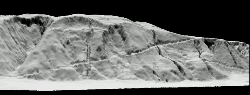
To the right is a view facing the
cliff, this surface has a "surfacezscale" applied to it so that the elevation
values are stretched. Stretching height of the surface exaggerates
things a bit, but it makes for good visualization because all the erosional
features are exaggerated.


To the left is a close-up perspective
view that shows the slide, it also shows the dimpled pattern of the interpolated
surface.
To the right is another panoramic
view with a smoothed surface.
Back
to Main La Conchita Page